


NY says FCC broadband data undercounts many without internet access
980 unserved in Orleans or 5.36%; Cattaraugus highest unserved in WNY at 21.44%
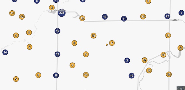
This area of the Town of Yates near Platten Road has several unserved areas (in yellow). Areas in blue are considered “served.”
Press Release, Gov. Kathy Hochul’s Office
Governor Kathy Hochul today announced that New York’s ConnectALL Office has submitted over 31,000 addresses from across the state to the Federal Communications Commission under the Broadband Data Collection challenge process.
The federal challenge process, which allows states to propose changes or updates to the FCC’s broadband maps, helps to better locate areas unserved or underserved by broadband. In doing so, these proposed changes inform federal funding decisions regarding broadband access and help to ensure that high-speed internet is available at every address in the country.
“Affordable, reliable broadband is an absolute necessity for accessing work, education, and important government services, and we can no longer afford to treat it like a luxury,” Governor Hochul said. “Thanks to our first-of-its-kind broadband mapping tool we have a clearer picture than ever about New York’s broadband needs and we are better able to advocate for federal funding and program support to fill those gaps. My administration remains committed to ensuring that families and businesses are well-connected to broadband, and I look forward to a continued partnership with local, state, and federal authorities to make high-speed internet available to all New Yorkers.”
The Commerce Department is expected to begin disbursing broadband funding from the Infrastructure Investment and Jobs Act (IIJA) to states and territories in late 2023 based largely on the proportion of unserved and underserved homes and businesses in each state, using maps created by the FCC. The FCC has begun by issuing a “map fabric” that is meant to include all addresses in the country, which they shared with all states and other stakeholders to challenge and improve.
This challenge was made possible due to New York’s first-of-its-kind, interactive broadband map (click here) launched earlier this year, which contains detailed information of the State’s broadband infrastructure down to the street-level. The challenge process is a critical step in determining New York’s funding allocation for broadband from the Infrastructure Investment and Jobs Act (IIJA). ConnectALL will continue to analyze the FCC maps.
The 31,798 records in the State’s challenge are all among the 138,598 addresses identified as unserved or underserved by the Department of Public Service’s (DPS) Broadband Assessment Program and include evidence that they meet the FCC’s definition for inclusion in the federal map. The ConnectALL Office collaborated with DPS and the Office of Information Technology Services (ITS) to analyze and challenge the FCC maps.
Editor’s Note: Orleans Hub checked the county data on the state’s map. Here are the breakdowns among Western New York counties:
- Orleans: unserved at 5.36% (980), 0% as underserved (0), 94.94% as served (17,305)
- Genesee: unserved at 5.26% (1,237), with another 0.14% as underserved (32), 94.6% as served (22,247)
- Wyoming: unserved at 12.72% (2,138), with another 0.41% as underserved (69) and 86.87% as served (14,604)
- Livingston: unserved at 10.14% (2,676), with another 0.70% as underserved (186) and 89.16% as served (23,538)
- Monroe: unserved at 0.86% (2,600), with another 0.02% as underserved (52) and 99.12% served (299,935)
- Niagara: unserved at 1.28% (1,205), with another 0% as underserved (0), 98.72% as served (93,063)
- Erie: unserved at 0.93% (3,277), with another 0.16% as underserved (561), 98.92% as served (350,172)
- Chautauqua: unserved at 3.61% (2,239), with another 1.93% as underserved (1,200), 94.45% as served (58,578)
- Cattaraugus: unserved at 21.44% (8,715), with another 4.03% as underserved (1,639), 74.53% as served (30,303)
- Allegany: unserved at 5.43% (1,379), with another 0.18% as underserved (45), 94.39% as served (23,960)
Empire State Development President, CEO and Commissioner Hope Knight said, “As we look to make broadband more affordable, accessible, and equitable, accurate maps are essential for the proper allocation of federal funding. New York State’s broadband mapping project provides clear and straightforward data on the State’s digital infrastructure and, by aligning the FCC maps with ours, we will ensure New York gets its fair share of federal dollars so every New Yorker has access to the internet when and where they need it.”
The initial map produced by New York’s Broadband Assessment Program was the result of months of field assessments conducted by the Public Service Commission in the state’s most remote areas, covering more than 80,000 miles. In order to collect accurate data, the Commission collaborated with 60 internet service providers and surveyed tens of thousands of New York consumers is continuing to collect broadband availability data from internet service providers and directly from New Yorkers to refine its map.
Prior to the creation of New York’s Broadband Assessment Program, New York, like most states, relied in part on federal data that only required broadband providers to deliver service to one address in a census block to designate the entire area as served. By collecting address-level data, New York is able to depict what locations are served, underserved, and unserved in a more granular way, which will aid in allocating state and federal funding.
Without this challenge, and unless the FCC updates its map, it will not be possible for the FCC to recognize those locations in New York as lacking broadband service and the state would miss out on much needed funding. The ConnectALL challenge could increase New York’s eligibility for a key source of IIJA funding by as much as 40 percent depending on the FCC’s and Commerce Department’s determinations.
The ConnectALL Office, along with DPS and the state’s team of GIS analysts, is continuing to analyze the FCC data to identify further potential challenges and is preparing to evaluate broadband availability data once the FCC releases that to the states.
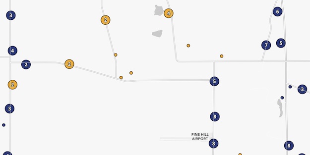
The state map identifies this part of Barre near Pine Hill with several unserved addresses.
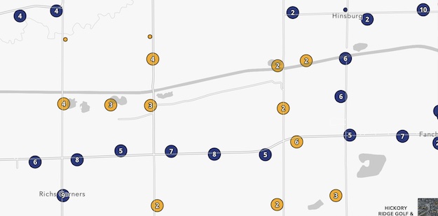
The Riches Corners Road area in Albion also has unserved areas for high-speed internet.
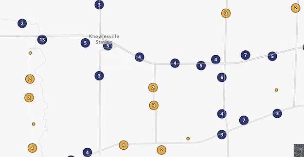
Parts of Knowlesville are also considered unserved on the state map.