


New historic marker celebrates Medina Aqueduct, an engineering marvel
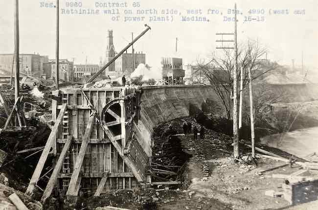
This 1913 photo shows construction of the aqueduct-dam on the north side of the canal basin.
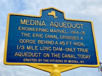
Provided photo: A historic marker has been installed in the canal basin to highlight the Medina Aqueduct, considered an engineering marvel. It is the only true aqueduct remaining on the Erie Canal.
MEDINA – A historic marker recognizing the significance of the Medina Aqueduct has been installed in the canal basin by the Medina DPW.
The Orleans Renaissance Group was the prime mover of the project and facilitated its design and fabrication with Catskill Castings in Bloomville.
The ORG believes recognition of this engineering marvel was way overdue, as the feature is unique on the canal and an often overlooked point of true historic significance, said Chris Busch, chairman of the ORG.
“Few people know that it’s there,” Busch said. “Now they not only know it’s there, but they’ll know how important it is to the history of the canal.”
The Barge Canal System begun in 1907 and completed in 1918, was a result of a report from the Committee on Canals, created by Governor Theodore Roosevelt in 1898. The Canal’s width was extended to 125 feet with a minimum depth of 12 feet.
During this enlargement of the canal, the problem of carrying the canal over the gorge at Oak Orchard River in Medina was the most studied engineering issue of the 1917 rebuild. At one point, engineers had considered removing the loop and moving the canal to a straighter path across the river, using a steel truss system.
The idea was abandoned and the result is what is seen today – a true engineering marvel. The concrete wall which holds back the canal is actually a dam and is longer than the Hoover Dam, with an aqueduct carrying the canal across the Oak Orchard River.
Following is an excerpt from History of the Barge Canal of New York State by NYS State engineer and surveyor Noble E. Whitford, 1922, and provides an assessment and description of the engineering required to create this section of the canal:
“Because of the difficulties involved in the problem of crossing the Oak Orchard in the village of Medina, a short stretch of canal in this vicinity became one of the most interesting portions of the whole line and received a greater amount of study than any other section.
Seven schemes (to cross the Oak Orchard) and their costs, which included simply the length of the canal across the gorge, were as follows:
(1) A steel cantilever structure with a steel trough for the canal, which was estimated to cost $500.
(2) A three-hinged steel arch of 300 feet span, center to center, carrying a steel trough for its length of 300 feet, the approaches of about a hundred feet on either side being concrete troughs supported on short concrete arches. The estimated cost was $405,000.
(3) The same steel arch and trough, but with approaches built all of steel, the cost being $407,000.
(4) A concrete arch in place of the steel arch, the remainder of the structure, both trough and approach supports, being of steel, at an estimated cost of $300,000.
(5) An all-concrete structure, consisting of a plain concrete trough on a concrete arch of 300 feet span, center to center, estimated at $272,000.
(6) The same concrete structure, but with architectural adornment, which would raise the cost to $285,000.
(7) An earth fill over a long culvert, the canal to be carried in a concrete trough, estimated to cost $433,000.
After careful consideration, the sixth scheme was adopted for making detailed plans on which to let a contract. The reasons for this choice were, briefly, this concrete structure was considered to be the safest, most permanent and cheapest to build, cheapest to maintain and the most pleasing in appearance.

This diagram shows the aqueduct-dam and Medina Falls north of Medina’s canal basin.
The canal as it was finally built in this vicinity, embodies several interesting engineering features, the most important being the long stretches of retaining wall, some of it unusually high, and the aqueduct over the creek.
Although the extent of canal under this contract was only 2 1/3 miles long, there was on the north side one continuous stretch of retaining wall nearly 7,000 feet long, while on the south side, two pieces together measured about 4,600 feet.
Between 1,500 and 1,600 feet of the north wall was high, extending in some places well below the canal bottom, to the natural surface as it sloped down toward the gorge.
Here, the bed of the canal is a rock fill and the wall beside the channel sustains hydrostatic pressure for its full height, which reaches a maximum of 45 feet. Thus, in effect, the canal runs behind a high dam for nearly a third of a mile.
As a preventative against leakage at this high wall, a vertical plate of steel was embedded six inches in each of two adjoining sections at the joints formed in construction.”
“This aqueduct feature may not be as glamorous as other sites along the canal, but as you can see it is of vital importance,” Busch said. “It was heavily studied and was a true feat of engineering for its day. ORG is happy to bring this important piece of history to light and its role in the history of the Erie Canal and hopes it is a source of pride for our community.”
Busch further added, “We are incredibly grateful for the generous financial support we received in bringing this important project to fruition. We would like to publicly recognize and thank those who contributed to this effort. It would not have been possible without them.”
In addition to ORG, generous financial support was provided by Medina Sandstone Society, Honorable James Punch and Gabrielle Barone.
“We also thank mayor Mike Sidari and the Medina Village Board for their cooperation in making this a reality,” Busch said. “Also, village historian Todd Bensley for his expert assistance and support, and DPW superintendent Jason Watts, along with the personnel of Medina DPW for executing an excellent installation of the marker.”
The marker is located in Medina’s Canal Basin and joins the numerous historic markers and interpretive signs throughout the village that tell the story of Medina along the village’s Heritage Trail.