July 4th marks bicentennial of Erie Canal construction
“Overlooked Orleans” – Volume 3, Issue 27
The Erie Canal has a long and illustrious history spanning over two hundred years starting on July 4, 2017. As we hit the bicentennial of the construction of the Canal, I thought it would be fitting to write a series of articles about some of the more interesting Canal images within the Department of History’s collections.
I suspect that the passing of the July 4th anniversary will go without fanfare locally, but the eight years between the start of construction and official opening will provide many opportunities to celebrate the iconic waterway.
Dating back to 1699, the concept of constructing a waterway that would open the wilderness of New York to the rest of the world was first suggested by a French engineer named Sebastien Vauban. The radical idea remained in the minds of entrepreneurs and politicians throughout the 18th century, surfacing again after the establishment of the United States. It was not until the early 1800s that the idea became a reality under the governorship of DeWitt Clinton.
The canal, opening on October 25, 1825, represented a feat of engineering that only few could have ever imagined. Without the aid of steam equipment, men relied on hand tools and animal power to excavate the 40-foot-wide, 4-foot-deep ditch that spanned over 360 miles.
According to Cary Lattin, shipping rates for wheat dropped from $.25 per bushel to $5.00 per ton, earning Western New York the title of “The Break Basket of the World.” The old Niagara Frontier went on to produce much of the wheat consumed by the United States up until the start of the Civil War.
The massive drop in shipping costs resulted in the expansion of the canal system starting in 1835. Over the following decades, the waterway was widened to seventy feet and deepened to seven feet; entire sections were rebuilt, new locks constructed, aqueducts erected, and some sections rerouted. The newly expanded canal allowed for businessmen to operate larger packet boats, which in turn carried more tonnage from Lake Erie to the Hudson River.
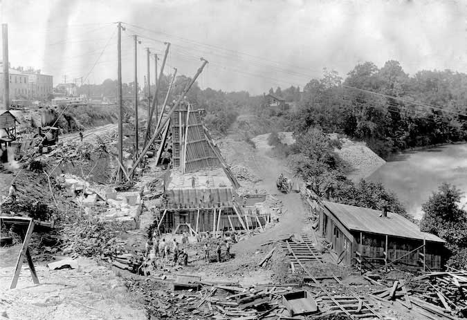
This image was taken during the second expansion, which officially started in 1903 when the New York State Legislature introduced a plan to form the New York State Barge Canal. The photographer directed his camera westward looking towards Church Street in Medina. In the distance, you can see the Church Street Bridge that spanned the original canal; a packet boat is visible travelling eastbound towards Albion. Also visible are buildings that lined the “heel path,” or southern towpath of the canal, providing valuable goods and services to passing boats.
I find this image to be an outstanding reflection of the extensive knowledge of engineering required to complete the massive expansion in Orleans County during the 1910s. Guy derricks were constructed to raise stone and cement to the top of the large wooden frames assembled to form the enormous retaining walls seen along Medina’s towpath. The relative size of the workers gathered near the base of the retaining wall gives perspective to the size of the work being completed.
Although we see the presence of a steam locomotive to the left, used to draw raw materials to the job site, a team of horses is visible pulling a piece of equipment up the tracks to the right. The gentleman standing atop the embankment wearing a suit and hat appears to be a supervisor, observing the work of the men below. A thorough observation of the photograph reveals men standing at various points on the framework of the retaining wall and one man standing upon the wall’s concrete foundation, directing the guy derrick operator to move the scoop to the south. One of the workers appears to have caught the photographer out of the corner of his eye and stopped to watch him take the photograph.
The expansion, which was completed in Orleans County approximately between 1912 and 1918, widened the canal to 120 feet from 70 feet and deepened it from 7 feet to 12 feet.
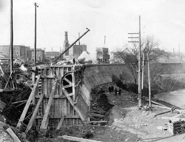
The second photograph shows men working on a portion of the retaining wall closer to the terminal in Medina. The Church Street Bridge approach is visible to the left and the White Hotel is likely the most prominent and recognizable structure in the photograph.


