


FEMA officials will present new flood maps in Orleans County at Oct. 12 meeting
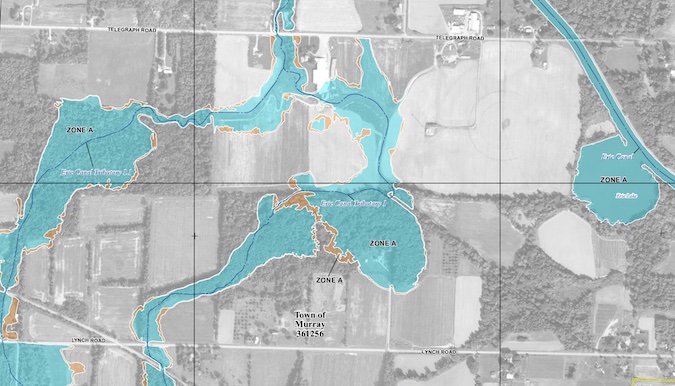
This updated flood map from FEMA shows most of the Town of Murray and the Village of Holley.
ALBION – Officials from the Federal Emergency Management Agency will be in Orleans County on Oct. 12 to present new flood maps.
FEMA officials and representatives from the state Department of Environmental Conservation will present the maps and will take input from the public from 3 to 7 p.m. on Oct. 12 at Hoag Library, 124 South Main St., Albion. (There is a chance the meeting will need to be rescheduled if there is a federal government shutdown.)
Emergency management officials at the county, state and federal level have been working to reduce the effects of severe weather and natural disasters.
FEMA issued the following press release about the flood maps and the meeting on Oct. 12:
On July 17, FEMA released preliminary Flood Insurance Rate Maps (FIRMs) for Orleans County for public comments. The new maps (click here) give updated information about communities’ flood risk and are used to identify areas that may require flood insurance coverage.
The previous maps for Orleans County were developed in the 1970s and ’80s and some areas show significant changes.
FEMA and the New York State Department of Environmental Conservation invite residents to learn if they were affected, and what actions can be taken to protect themselves.
The open house doesn’t include a formal presentation. Residents can attend at any time between 3 and 7 p.m., for any length of time. At the open house, residents will be able to talk one-on-one with FEMA representatives, to learn more about their flood risk and to get information on potential changes to flood insurance rates and requirements.
If you already have flood insurance, please bring a copy of your declaration page. Residents can also see preliminary versions of the Flood Insurance Study report and the FIRMs here. They can also see the updated preliminary maps compared to the old paper maps using the Old Paper Effective vs. New Digital Preliminary Data viewer.
The previous FIRMs for Orleans County were paper maps dating from the 1970s and 1980s. Because they will be available online, the new maps provide an additional level of transparency for residents. They also help community members make decisions about how to protect themselves from future flood events. The maps and FIS report are the basis for each community’s floodplain management regulations.
Due to these map changes, some properties in Orleans County may no longer be in the high-risk flood zone, known as the Special Flood Hazard Area. If the building will be outside the high-risk flood zone on the new FIRM, flood insurance is no longer federally required. Flood insurance is still recommended, for both homeowners and renters.
Some properties may be included in a high-risk flood zone for the first time. This may lead to those affected property owners being required to buy flood insurance. Flooding is the number one natural disaster in the United States. Community members should know their current flood risk and use the available tools and programs to make their property and community safer.
To request a reasonable accommodation (sign language, real-time captioning or other), please email Michael.Foley3@fema.dhs.gov or FEMA-CivilRightsOffice@fema.dhs.gov, or call (833) 285-7448, FEMA’s Civil Rights Resource Line.
To learn more or to access the flood maps, visit FEMA’s Flood Map Service Center at msc.fema.gov. Visit floodsmart.gov to learn about flood insurance. You may also contact a map specialist at the FEMA Mapping and Insurance eXchange (FMIX) at (877) 336-2627 or FEMA-FMIX@fema.dhs.gov.