County planners recommend against zoning map changes for Holley
Village needs to first fully update comprehensive plan and zoning texts

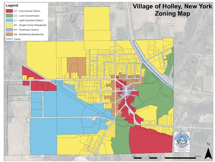
Courtesy of Orleans County Department of Planning & Development: This map shows the zoning districts in the Village of Holley.
HOLLEY – The Village of Holley is looking to update its zoning map, including a large parcel of land on Bennetts Corners Road as commercial, an expansion of the light industrial zone going south of the railroad tracks, and more land designated as conservation near the Holley Waterfalls.
The Orleans County Planning Board recommended against the changes right now, saying the village first needs to update the comprehensive plan and zoning texts. Changing the map is the last step in the process, Planning Board members said during their meeting last Thursday.
Holley hasn’t updated the map since 2008. The village is working to update the comprehensive plan.
Jeff Martin, a local attorney and Holley resident, said the village has the steps in the process out of order. He said the village also needs to do a “type 1 action” or the longer environmental impact study because more than 25 acres are being rezoned.
Martin said about 40 percent of the total village acreage would be rezoned as part of the updated zoning map.
He is most concerned with rezoning 60 acres on Bennetts Corners Road near Route 31. A developer from Chicago wants to develop that agricultural land into a banquet facility with 100 parking spaces. Martin and another neighbor, Roger Passarell, would have that facility within view of their backyards. They both attended Thursday’s Planning Board meeting.
Martin said the zoning map change appears to be an effort “to legitimize this for the developer without going through the normal process of comprehensive plan and zoning amendments.”
Mylynda Kuba, Holley’s former code enforcement officer, said the village has already passed local laws for some of the zoning map changes, especially in the downtown business district.
“There are currently a lot of open zoning areas,” she said. “The current map doesn’t work. There’s a lot that needs to be done in the Village of Holley.”


