


Atlas of Orleans County, sold as Fair fundraiser in 1967, has lasting historical value
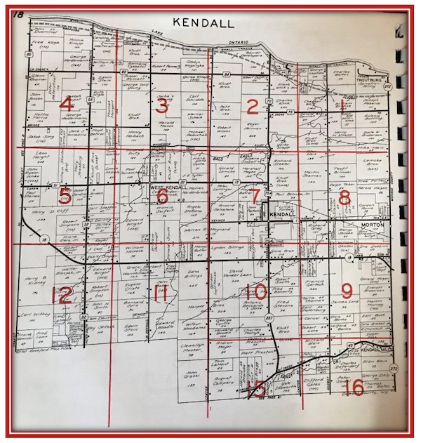
Plat map of Kendall, NY, 1967
By Catherine Cooper, Orleans County Historian
Illuminating Orleans, Vol. 3, No. 25
KNOWLESVILLE – In 1967, the Orleans County 4-H Leader’s Association undertook a variety of fundraising projects to help finance improvements at the newly acquired Fairgrounds in Knowlesville.
One of those projects – the publication of an Atlas and Plat Book of Orleans County – has proven to be of lasting historical value. This was a very appropriate choice for an agricultural county since plat maps show a visual overview of land ownership by town.
The 1967 publication was spiral bound, with a green cover and an aerial view of the Fairgrounds. Ten separate town maps showed the location of farms and listed the farm owners. An Index to Owners listed every landowner in the county whose name appeared in the township maps with location references to the appropriate page and map of the county, a business directory, and a listing of government officials.
Town assessors were offered $10 ($90 approx. currently) each to provide base maps of their townships for the publication. Five of the ten returned the payment to the committee.
The Albion Rotary Club voted to handle the sale of advertising to finance the publication. In exchange, the Club received a share of the overall profit which supported a Rotary Hospital in Bolivia.
4-H Agent Robert F. Stuerzebecher was chairman of the Rotary’s farm plat book committee which also included Sidney Cleveland, Thomas Heard and Richard Bloom. Paul Klatt of Lyndonville headed the Orleans County 4-H Leaders’ Association plat book committee. This was an ambitious project. The books were available from the County Extension Service and cost $2.50, ($22 approx. currently). A second plat book was published in 1972.
Both were produced by Rockford Map Publishers of Rockford, Il. which pioneered this map resource in 1944. Their first maps were hand drawn, but the process was soon mechanized to supply demand. With an emphasis on accuracy, the process involved the use of aerial photographs in conjunction with the base maps provided by the townships. Ownership information was then verified at the county courthouse.
The information so clearly laid out in these plat maps was no doubt of great interest to farmers. Real estate, banking and insurance companies also found them to be a valuable resource. As a historical record, plat maps document the historical ownership of land and are an invaluable resource for genealogists and local historians.
Additionally, the advertisements included provide a snapshot of businesses and services at a particular time.
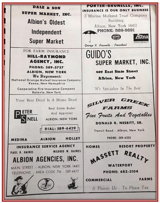
Advertisements from the 1967 Orleans County Plat book.
Digitization has enhanced the creation and possibilities of plat maps. Geo-referenced maps can be used on smartphones. Transparent plat maps may be overlaid over Google Earth. Whatever method is used, the fundamental issue of interest to individuals and business interests is “Who owns the land?”


