


8 to 16 inches of snow expected next 2 days
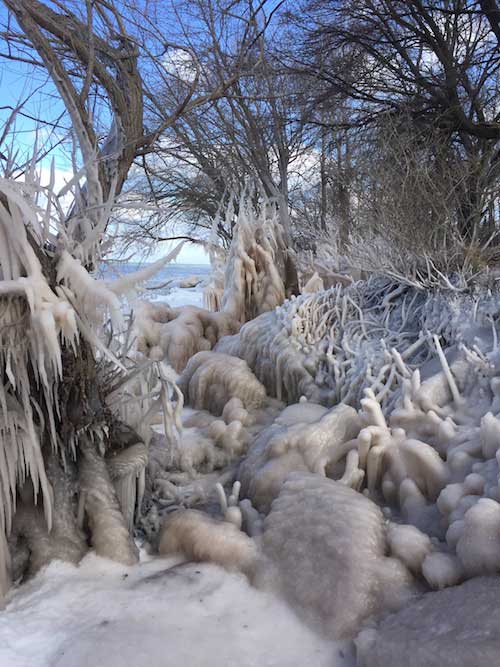
Tami Slingerland took these photos of an icy Lake Ontario shoreline on Sunday at the Yates Town Park.
A winter storm is expected to drop 8 to 16 inches on Orleans County from Monday evening through Wednesday, according to the National Weather Service in Buffalo.
The snowfall includes 1 to 3 inches tonight, 3 to 5 inches Tuesday, another 3 to 5 inches on Tuesday night, and 1 to 3 inches on Wednesday.
The Weather Service said visibility could be as low as a half mile at times from the heavy and blowing snow.
Governor Andrew Cuomo has activated the State Emergency Operations Center for Monday evening to prepare and respond to the Nor’easter that is expected to reach New York State late Monday night.
State agencies have already pre-positioned personnel, assets, and state stockpile resources – including sandbags, generators and pumps – to areas of the state where the storm will be at its strongest.
With the snow storm approaching, the Governor urges commuters to drive with caution for the Tuesday morning and afternoon commutes, and to avoid unnecessary travel. Motorists, especially tractor trailers, should be prepared for road closures across the state.
“In preparation for blizzard-like conditions, I will be activating the State Emergency Operations Center and have directed state agencies to continue proactively preparing communities and roadways for this major storm,” Cuomo said late this morning. “We remain in constant contact with local officials in every region, as New York prepares to aggressively clear roads, provide personnel and storm equipment as needed, and offer immediate assistance to communities across the state. I strongly urge everyone to limit unnecessary travel on Tuesday, and if you must drive, please plan ahead, be careful, and stay safe.”
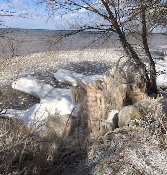
The Yates Town Park is located off Morrison Road.
Snow is expected to cover Upstate New York, where 12 to 16 inches of snow is anticipated in Western New York, the Finger Lakes, and Central New York regions with higher totals in higher elevations likely.
The heaviest snow accumulations are expected south and east of the of the Capital Region where 12 to 18 inches of snow is expected from late Monday night through late Tuesday night. Peak snowfall will be Tuesday and snow may linger in the higher elevations into Wednesday.
Snow will move into the lower Mid-Hudson Valley, New York City and Long Island regions after midnight on Monday.
Driving will be especially hazardous on Tuesday for both the morning and evening commutes, according to a news release from Cuomo’s Office. Minor coastal flooding is also expected during high tide. Residents in these regions should expect possible closures, delays and cancellations, and regularly monitor for updated information to plan ahead.